ملف:Lava Flow on Volcán de Fuego, 2016.jpg

Lava_Flow_on_Volcán_de_Fuego,_2016.jpg(720 × 480 بكسل حجم الملف: 315 كيلوبايت، نوع MIME: image/jpeg)

الوصف
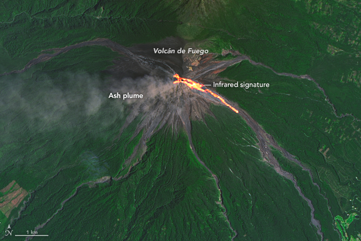
English: On September 7, 2016, the Operational Land Imager (OLI) on Landsat 8 captured this image of lava spilling down the slopes of Guatemala’s Volcán de Fuego, one of Central America’s most active volcanoes.

According to reporting from the Instituto Nacional de Sismologia, Vulcanologia, Meteorologia, e Hidrologia (INSIVUMEH), the latest bout of activity began on September 4, when lava rose as high as 200 meters (650 feet) above Fuego’s crater rim. Plumes of ash have reached heights of about 850 meters (2,800 feet).

The image is a composite of natural color (OLI bands 4-3-2) and shortwave Infrared (OLI band 7). Shortwave infrared light (SWIR) is invisible to the naked eye, but strong SWIR signals indicate increased temperatures.

The volcano is located about 70 kilometers (40 miles) west of Guatemala City, Guatemala.
التاريخ acquired September 7, 2016
المصدر http://earthobservatory.nasa.gov/IOTD/view.php?id=88722&src=eoa-iotd
المؤلف NASA Earth Observatory image by Joshua Stevens, using Landsat data from the U.S. Geological Survey.
الترخيص
(إعادة استخدام هذا الملف)
Public domain يقع هذا العمل في النِّطاق العامّ في الولايات المُتحدة الأمريكيَّة لأَنَّه عملٌ خالِصٌ من إِنتاج وكالة الفضاء الأمريكيَّة. تنصُ حقوق التَّأليف والنَّشر الخاصَّة بوكالة الفضاء الأمريكيَّة على أنَّ "أعمال الوكالة غير مَحميَّة بحقوق التَّأليف والنَّشر ما لم يُذكر خلافُ ذلك". لمزيدٍ من المعلومات انظر القالِب {{PD-USGov}} وصفحة حقوق التَّأليف والنَّشر الخاصَّة بالوكالة وصفحة سياسة الصُّور الخاصَّة بمُختبر الدَّفع النَّفَّاث.
تنبيهات:

الشروحات

أضف شرحاً من سطر واحد لما يُمثِّله هذا الملف

العناصر المصورة في هذا الملف

يُصوِّر

تاريخ الملف

اضغط على زمن/تاريخ لرؤية الملف كما بدا في هذا الزمن.

زمن/تاريخصورة مصغرةالأبعادمستخدمتعليق
حالي00:54، 24 سبتمبر 2016تصغير للنسخة بتاريخ 00:54، 24 سبتمبر 2016720 × 480 (315 كيلوبايت)commonswiki>Tillman{{Information |Description ={{en|1=On September 7, 2016, the Operational Land Imager (OLI) on Landsat 8 captured this image of lava spilling down the slopes of Guatemala’s Volcán de Fuego, one of Central America’s most active volcanoes. Accord...

ال1 ملف التالي مكررات لهذا الملف (المزيد من التفاصيل):

الصفحة التالية تستخدم هذا الملف:

بيانات وصفية