ملف:Europe 1748-1766 en.png

حجم هذه المعاينة: 800 × 570 بكسل. الأبعاد الأخرى: 320 × 228 بكسل | 640 × 456 بكسل | 1٬024 × 730 بكسل | 1٬280 × 913 بكسل | 2٬560 × 1٬825 بكسل | 3٬872 × 2٬761 بكسل.
الملف الأصلي (3٬872 × 2٬761 بكسل حجم الملف: 1٫26 ميجابايت، نوع MIME: image/png)
| هذا ملف من ويكيميديا كومنز. معلومات من صفحة وصفه مبينة في الأسفل. كومنز مستودع ملفات ميديا ذو رخصة حرة. |

|
هذه map of europe الصورة / الصورتان باستعمال رسومات متجهية ملفات رسوميات شعاعية.
It is recommended to name the SVG file "Europe 1748-1766 en.svg" - then the template Vector version available (or Vva) does not need the new image name parameter.
|
_en.png)
.png)
.jpg)
ملخص
| الوصف |
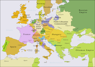
Deutsch: Diese Karte zeigt Europa in den Jahren nach dem Frieden von Aachen 1748 und in der Zeit des Siebenjährigen Krieges (1756-1763). Bis 1766 kam es zu keinen größeren geographischen Veränderungen in Europa.
Die Arbeit wurde mit Inkscape erstellt und beruht hauptsächlich auf einer Karte in: Putzger - Historischer Weltatlas, Berlin 1990, S.78f.
English: This map shows Europe in the years after the Treaty of Aix-la-Chapelle 1748 and the Seven Years' War (1756-1763). Europe did not see another major geographical change until 1766. The red line marks the borders of the Holy Roman Empire.
The work was created with Inkscape and is mainly based on a map in: Putzger - Historischer Weltatlas, Berlin 1990, 78 pp.
Français : Cette carte montre l'Europe dans les années après le Traité d'Aix-la-Chapelle (1748) et pendant les années de la Guerre des Sept Ans (1756-1763). L'Europe n'a pas vu un autre changement géographique important jusqu'à 1766.
Le travail a été créé avec Inkscape et il est basé principalement sur une carte dans: Putzger - Historischer Weltatlas, Berlin 1990, 78 pp.
Polski: Ta mapa ukazuje Europę w latach po pokoju w Akwizgranie z 1748 i wojnie siedmioletniej (1756-1763). Europa nie uświadczyła żadnych poważniejszych zmian geograficznych aż do 1766. Czerwona linia znaczy granice Świętego Cesarstwa Rzymskiego.
Praca została stworzona z użyciem Inkscape i powstała głównie na bazie mapy w: Putzger - Historischer Weltatlas, Berlin 1990, 78 pp.
Русский: Эта карта представляет Европу после заключения Аахенского мира в 1748 г. и во время Семилетней войны (1756-1763 гг.). До 1766 г. эта картина Европы не исменилась.
Эта работа нарисована с помощью программы Inkscape и основана на карте из книги: Putzger - Historischer Weltatlas, Berlin 1990, 78 cc. |
| التاريخ | |
| المصدر |
هذا الملفُّ مُشتقٌ مِن : Europe 1748-1766.png |
| المؤلف | P. S. Burton |
ترخيص
أنا، صاحب حقوق التأليف والنشر لهذا العمل، أنشر هذا العمل تحت الرخصة التالية:
هذا الملف مُرخص تحت رخصة المشاع المبدع نسبة المصنف إلى مؤلفه 3.0 العامة
- يحقُّ لك:
- مشاركة العمل – نسخ العمل وتوزيعه وبثُّه
- إعادة إنتاج العمل – تعديل العمل
- حسب الشروط التالية:
- نسب العمل إلى مُؤَلِّفه – يلزم نسب العمل إلى مُؤَلِّفه بشكل مناسب وتوفير رابط للرخصة وتحديد ما إذا أجريت تغييرات. بالإمكان القيام بذلك بأية طريقة معقولة، ولكن ليس بأية طريقة تشير إلى أن المرخِّص يوافقك على الاستعمال.
تاريخ الملف
اضغط على زمن/تاريخ لرؤية الملف كما بدا في هذا الزمن.
| زمن/تاريخ | صورة مصغرة | الأبعاد | مستخدم | تعليق | |
|---|---|---|---|---|---|
| حالي | 01:48، 16 يوليو 2018 | | 3٬872 × 2٬761 (1٫26 ميجابايت) | commonswiki>Bryanrutherford0 | Added the Ionian Islands, made the Duchy of Milan a Habsburg possession |
استخدام الملف
ال1 ملف التالي مكررات لهذا الملف (المزيد من التفاصيل):
- ملف:Europe 1748-1766 en.png من ويكيميديا كومنز
الصفحتان التاليتان تستخدمان هذا الملف: