|
تضامنًا مع حق الشعب الفلسطيني |
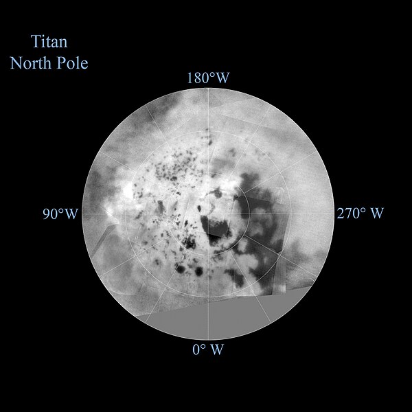
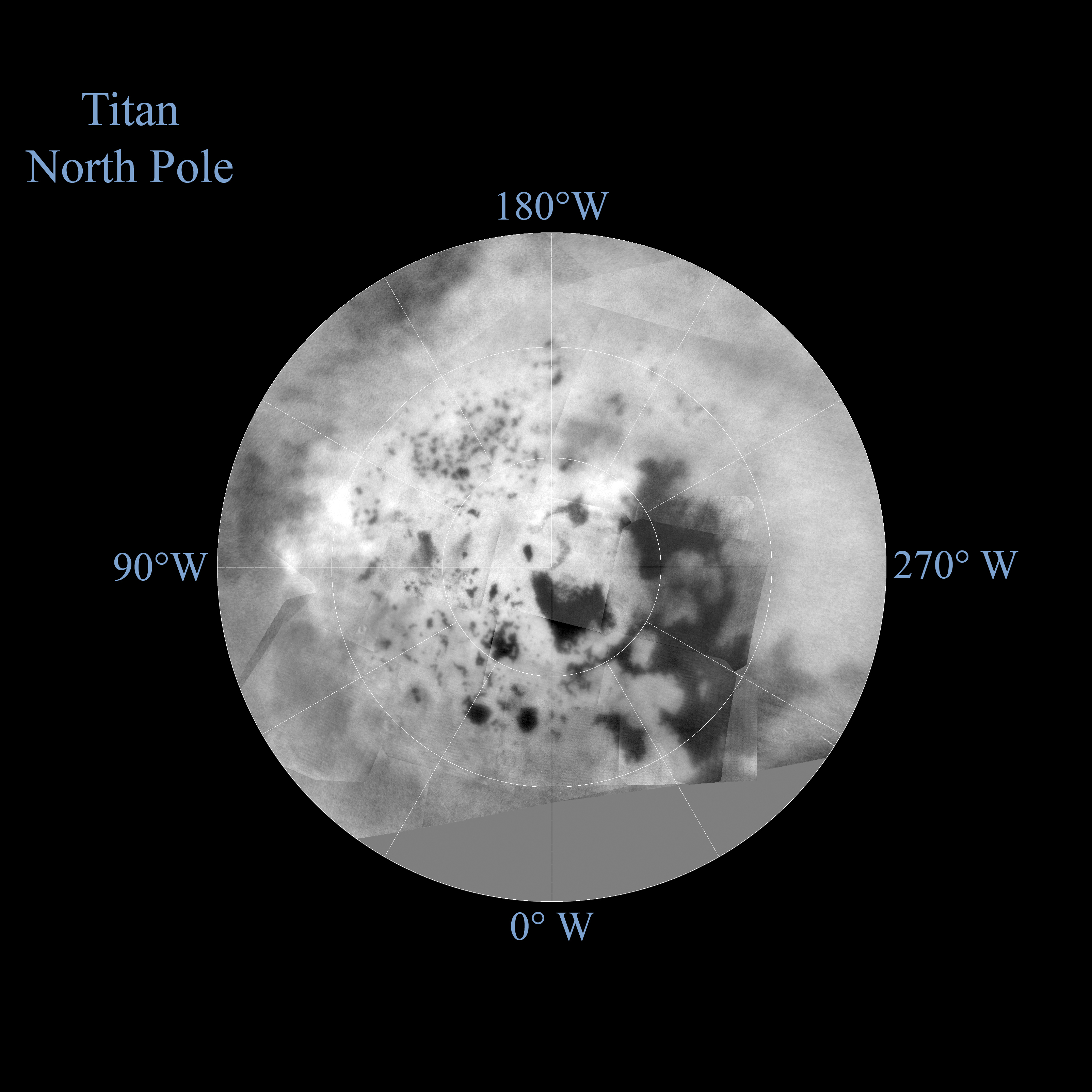
ملف:PIA19657-SaturnMoon-Titan-NorthPole-20140407.jpg

الملف الأصلي (3٬208 × 3٬208 بكسل حجم الملف: 2٫21 ميجابايت، نوع MIME: image/jpeg)
| هذا ملف من ويكيميديا كومنز. معلومات من صفحة وصفه مبينة في الأسفل. كومنز مستودع ملفات ميديا ذو رخصة حرة. |
ملخص
| الوصف |
English: PIA19657: Titan Polar Maps - 2015 - North Pole
http://photojournal.jpl.nasa.gov/catalog/PIA19657 The northern and southern hemispheres of Titan are seen in these polar stereographic maps, assembled in 2015 using the best-available images of the giant Saturnian moon from NASA's Cassini mission. The images were taken by Cassini's imaging cameras using a spectral filter centered at 938 nanometers, allowing researchers to examine variations in albedo (or inherent brightness) across the surface of Titan. These maps utilize imaging data collected through Cassini's flyby on April 7, 2014, known as "T100." Titan's north pole was not well illuminated early in Cassini's mission, because it was winter in the northern hemisphere when the spacecraft arrived at Saturn. Cassini has been better able to observe northern latitudes in more recent years due to seasonal changes in solar illumination. Compared to the previous version of Cassini's north polar map (see PIA11146), this map provides much more detail and fills in a large area of missing data. The imaging data in these maps complement Cassini synthetic aperture radar (SAR) mapping of Titan's north pole (see PIA17655). The uniform gray area in the northern hemisphere indicates a gap in the imaging coverage of Titan's surface, to date. The missing data will be imaged by Cassini during flybys on December 15, 2016 and March 5, 2017. Lakes are also seen in the southern hemisphere map, but they are much less common than in the north polar region. Only a lakes have been confirmed in the south. The dark, footprint-shaped feature at 180 degrees west is Ontario Lacus; a smaller lake named Crveno Lacus can be seen as a very dark spot just above Ontario. The dark-albedo area seen at the top of the southern hemisphere map (at 0 degrees west) is an area called Mezzoramia. Each map is centered on one of the poles, and surface coverage extends southward to 60 degrees latitude. Grid lines indicate latitude in 10-degree increments and longitude in 30-degree increments. The scale in the full-size versions of these maps is 4,600 feet (1,400 meters) per pixel. The mean radius of Titan used for projection of these maps is 1,600 miles (2,575 kilometers). The Cassini mission is a cooperative project of NASA, ESA (the European Space Agency) and the Italian Space Agency. The Jet Propulsion Laboratory, a division of the California Institute of Technology in Pasadena, manages the mission for NASA's Science Mission Directorate, Washington. The Cassini orbiter and its two onboard cameras were designed, developed and assembled at JPL. The imaging operations center is based at the Space Science Institute in Boulder, Colorado. For more information about the Cassini-Huygens mission visit http://saturn.jpl.nasa.gov and http://www.nasa.gov/cassini. The Cassini imaging team homepage is at http://ciclops.org. |
| التاريخ | |
| المصدر | http://photojournal.jpl.nasa.gov/figures/PIA19657_fig2.jpg |
| المؤلف | NASA/JPL-Caltech/Space Science Institute |
ترخيص
| يقع هذا العمل في النِّطاق العامّ في الولايات المُتحدة الأمريكيَّة لأَنَّه عملٌ خالِصٌ من إِنتاج وكالة الفضاء الأمريكيَّة. تنصُ حقوق التَّأليف والنَّشر الخاصَّة بوكالة الفضاء الأمريكيَّة على أنَّ "أعمال الوكالة غير مَحميَّة بحقوق التَّأليف والنَّشر ما لم يُذكر خلافُ ذلك". لمزيدٍ من المعلومات انظر القالِب {{PD-USGov}} وصفحة حقوق التَّأليف والنَّشر الخاصَّة بالوكالة وصفحة سياسة الصُّور الخاصَّة بمُختبر الدَّفع النَّفَّاث. | ||
 |
تنبيهات:
|
تاريخ الملف
اضغط على زمن/تاريخ لرؤية الملف كما بدا في هذا الزمن.
| زمن/تاريخ | صورة مصغرة | الأبعاد | مستخدم | تعليق | |
|---|---|---|---|---|---|
| حالي | 01:54، 10 أكتوبر 2015 | | 3٬208 × 3٬208 (2٫21 ميجابايت) | commonswiki>Drbogdan | User created page with UploadWizard |
استخدام الملف
ال1 ملف التالي مكررات لهذا الملف (المزيد من التفاصيل):
- ملف:PIA19657-SaturnMoon-Titan-NorthPole-20140407.jpg من ويكيميديا كومنز
الصفحة التالية تستخدم هذا الملف: