|
تضامنًا مع حق الشعب الفلسطيني |
ملف:Civilizations map.png

الملف الأصلي (1٬427 × 634 بكسل حجم الملف: 41 كيلوبايت، نوع MIME: image/png)
| هذا ملف من ويكيميديا كومنز. معلومات من صفحة وصفه مبينة في الأسفل. كومنز مستودع ملفات ميديا ذو رخصة حرة. |
ملخص
| الوصف |
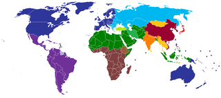
English: A map of civilizations, loosely based (see below) on Huntington's 1996 "Clash of Civilizations" (p. 26).
The NINE "civilizations" identified by Huntington are:
Other colors should indicate (light green, turquoise) the cultural fault lines where the clash of civilizations will occur. There are nine blocks shown in the original 1996 map. The additional colors, including the "fault line" countries in light green or turquoise are due to the judgement of the uploaders/creators of this map, not to Huntington. Other differences from the original map:
Español: Un mapa de civilizaciones, basado libremente (ver abajo) en el "Choque de civilizaciones" de Huntington en 1996 (p.26).
Las NUEVE "civilizaciones" identificadas por Huntington son:
Otros colores deben indicar (verde claro, turquesa) las fallas culturales donde ocurriera el choque de civilizaciones. Hay nueve bloques que se muestran en el mapa original de 1996. Los colores adicionales, incluidos los países de la "línea de falla" en color verde claro o turquesa, se deben a la opinión de los usuarios/creadores de este mapa, no a Huntington. Otras diferencias del mapa original:
Русский: Карта этнокультурного разделения цивилизаций, построенная по концепции Хантингтона.
עברית: תשע ה"ציביליזציות" שזוהו על ידי הנטינגטון הן:
Suomi: Tähän tulee suomenkielinen teksti. A map of civilizations, loosely based (see below) on Huntington's 1996 "Clash of Civilizations" (p. 26).
The NINE "civilizations" identified by Huntington are:
|
| التاريخ | |
| المصدر | عمل شخصي (Usergreatpower) |
| المؤلف | Usergreatpower في ويكيبيديا الإنجليزية |
| إصدارات أخرى | File:Clash of Civilizations map.png |
ترخيص
| وضع -Usergreatpower في ويكيبيديا الإنجليزية-، وهو المؤلف، هذا العمل في النِّطاق العامِّ. يسري ذلك في كل أرجاء العالم. في بعض البلدان، قد يكون هذا التَّرخيص غيرَ مُمكنٍ قانونيَّاً، في هذه الحالة: يمنح Usergreatpower الجميع حق استخدام هذا العمل لأي غرض دون أي شرط ما لم يفرض القانون شروطًا إضافية. |
سجلُّ الرَّفع الأصيل
- 2008-11-20 23:07 Usergreatpower 1427×742× (55694 bytes) {{Information |Description=Clash of Civilisations map |Source=I created this work entirely by myself. |Date=20/11/2008 |Author=~~~ |other_versions= }}
| الشروح | هذه الصورة مشروحة: أظهر الشروح في كومنز |
تاريخ الملف
اضغط على زمن/تاريخ لرؤية الملف كما بدا في هذا الزمن.
| زمن/تاريخ | صورة مصغرة | الأبعاد | مستخدم | تعليق | |
|---|---|---|---|---|---|
| حالي | 23:49، 16 مايو 2020 | | 1٬427 × 634 (41 كيلوبايت) | commonswiki>Babelia | According to the book, Argentina is Latin American (despite the white majority and the southern European cultural influence) |
استخدام الملف
ال1 ملف التالي مكررات لهذا الملف (المزيد من التفاصيل):
- ملف:Civilizations map.png من ويكيميديا كومنز