|
تضامنًا مع حق الشعب الفلسطيني |
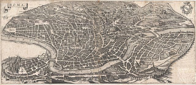
ملف:1652 Merian Panoramic View or Map of Rome, Italy - Geographicus - Roma-merian-1642.jpg
اذهب إلى التنقل
اذهب إلى البحث

حجم هذه المعاينة: 800 × 348 بكسل. الأبعاد الأخرى: 320 × 139 بكسل | 640 × 279 بكسل | 1٬024 × 446 بكسل | 1٬280 × 557 بكسل | 2٬560 × 1٬114 بكسل | 6٬000 × 2٬611 بكسل.
الملف الأصلي (6٬000 × 2٬611 بكسل حجم الملف: 6٫6 ميجابايت، نوع MIME: image/jpeg)
| هذا ملف من ويكيميديا كومنز. معلومات من صفحة وصفه مبينة في الأسفل. كومنز مستودع ملفات ميديا ذو رخصة حرة. |
| Roma. | ||||||
|---|---|---|---|---|---|---|
| الفنان | ||||||
| العنوان |
Roma. |
|||||
| الوصف |
English: An important and stunning c. 1641 bird's eye view and map of Rome by Matthus Merian. Merian's panoramic view of Rome, based on the eastward oriented model established in 1593 by Antonio Tempesta, reveals the city at the height of the Italian Renaissance. This map follows shortly after Pope Sixtus the Fifth's ambitious civic redesign of Rome and yet predates the massive rebuilding that occurred during the Baroque Period, thus encapsulating the city during an ephemeral but significant period. The axonometric projection that Merian utilizes lends this map a special significance to historians and architects who can thus visualize many buildings that were demolished or fell into ruin during the subsequent era. The Column of Antononi the Pious, for example, is depicted in its full glory, including its magnificent base. One might suppose, from 1703 excavation records, that most of the column, including the base, was buried in the 17th century, but here full knowledge of the column's form and design are evident - a mystery. This map also includes some of the only surviving visual representations of Rome's early churches, many of which were replaced with grander structures in the 18th century. Issued for inclusion in Matthuas Merian's 1642 Topographia Germaniae . Though we can have no idea of how many of this map Merian originally printed, nor how many have survived to this day, we have identified roughly 21 examples in major institutional collections as well as, presumably, any number of additional examples in private hands. |
|||||
| التاريخ | ١٦٤٢ (undated) | |||||
| الأبعاد | ارتفاع: ١٢٫٥ إنش (٣١٫٧ سم)؛ عرض: ٢٨٫٥ إنش (٧٢٫٣ سم) | |||||
| رقم التصنيف |
وصلة موقع جيوغرافيكوس: Roma-merian-1642 |
|||||
| المصدر/المصور |
Merian, M., Topographia Germaniae, 1642.
|
|||||
| الترخيص (إعادة استخدام هذا الملف) |
|
|||||
تاريخ الملف
اضغط على زمن/تاريخ لرؤية الملف كما بدا في هذا الزمن.
| زمن/تاريخ | صورة مصغرة | الأبعاد | مستخدم | تعليق | |
|---|---|---|---|---|---|
| حالي | 16:58، 24 مارس 2011 | | 6٬000 × 2٬611 (6٫6 ميجابايت) | commonswiki>BotMultichillT | {{subst:User:Multichill/Geographicus |link=http://www.geographicus.com/P/AntiqueMap/Roma-merian-1642 |product_name=1652 Merian Panoramic View or Map of Rome, Italy |map_title=Roma. |description=An important and stunning c. 1641 bird's eye view and map of |
استخدام الملف
ال1 ملف التالي مكررات لهذا الملف (المزيد من التفاصيل):
الصفحة التالية تستخدم هذا الملف: